Limmernsee

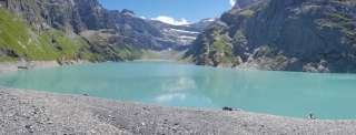
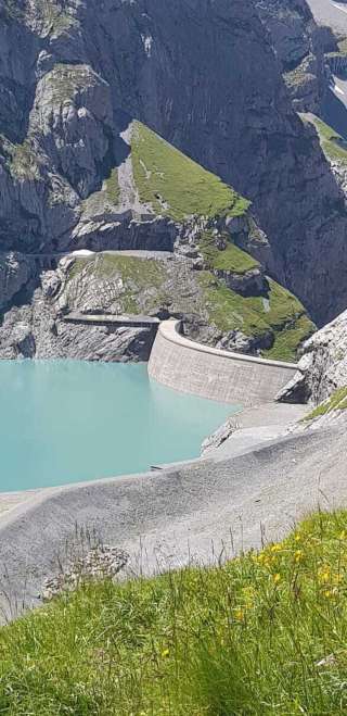
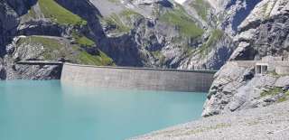
The Limmernsee dam is an arch dam and 146 metres high. It is 370 metres long and 9 metres wide in the area of the crown. The foundation measures 25 meters in width. Lake Limmern has a reservoir volume of 92 million cubic metres. With the Tierfed - Chalchtrittli cable car: From the Chalchtrittli mountain station, a marked hiking trail leads through the power plant tunnel (approx. 3 km) to Lake Limmern. Hike via Pantenbrugg: From Tierfed via Pantenbrugg to Baumgartenalp and from there to Chalchtrittli. Ascent approx. 1100 m / approx. 3h 15 min. From there through the tunnel in about 30 minutes to Lake Limmern. Hike on to the Muttseehütte SAC: Ascent approx. 630 m / approx. 1h 45 min. The Limmernsee is located in the former headwaters of the Limmernbach in the Limmernboden in the rearmost part of the Limmerntal. The lake is fed by the meltwater from the Griess and Limmern glaciers as well as the surrounding mountain ranges. The two glaciers are located on the north side of the Bifertenstock (3419 m) southwest of the reservoir. In the northern part of the lake, the Muttenbach flows in, through which the meltwater of the Latten and the Muttenalp drains. After leaving the lake, the Limmernbach flows through the Limmerntal. On its way to the Üelialp, where it flows into the Linth, it picks up various small mountain streams from the left and right. Lake Limmeren is surrounded by high mountains. Thus, in addition to the Bifertenstock, on the west side of the lake are the Selbsanft Mountains (with heights up to 3029 m), to the north the Muttenchopf (2482 m), to the northeast the Muttenstock (3088 m), to the east the Muttenbergen (with heights up to 2954 m) and to the southeast the Kistenstöckli (2747 m).
Price information


Event date


Fehler melden (ID: plc_s9t_hasttihi-gqdi-edcs-jdve-rjcqjcetdgsh)