Guppen landslide landscape

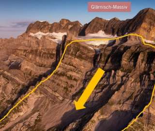
In front of the impressive backdrop of Vorderglärnisch and Vrenelisgärtli, you can see a partly wooded sharp erosion ridge. It marks the massive debris fan of the Guppen landslide, which flowed over the ground moraines of the Linth glacier towards the end of the last ice age.
Below the Mittelguppen, a large detachment niche begins at an altitude of 1200 meters. It extends upward to the lower edge of the Guppen glacier at an altitude of 2300 meters. The enormous debris mass of 800,000,000 cubic meters of rock rolled over the area of Schwändi and Mitlödi and finally collided on the opposite side of the valley in the area of the present-day village of Sool.
The deposited rock masses formed a barrier that separated the Glarner Mittelland from the hinterland. A reservoir lake formed that extended at least as far as Luchsingen. Due to the damming, the Linth and the Sernf were forced to deposit their sediment behind the barrier. The sediment build-up at Schwanden was about 70 meters higher than today’s Linth bed but was eroded again by the Linth over time.
Look back to this time on an easy hike over the former landslide debris of the Guppen landslide.
Guided tours are offered by geo-life
Live on the go - with the Sardona Aktiv App!
Additional info
| Duration | 2 hours 30 minutes |