Rundwanderung Ober Lochegg mit Fridlispitz

Alpine paths and rock climbing
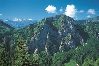
The Wageten stands like a backdrop above the entrance to the Niederurn valley, with furrowed screes rising abruptly from the dense edge of the forest. It is easier to reach the eye-catching Alpine edge mountain from the Oberurin Valley, because there the gentle slopes of the Lochegg-Alp reach almost to the summit ridge. The change of perspective of the Lochegg crossing and the final circumnavigation of the Fridlispitz are further plus points of this route.
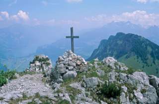
In Oberurnen, the signs are "Lochegg". First, a winding asphalt road winds its way up the back of the Bergli in the Oberuri valley. Wonderful views of Lake Walen soften the monotony of hairpin bends. From Tschingel (1010 m) the route dives into pasture land on a bad trail. Later, the terrain flattens out, the forest remains behind and reveals the green meadows of Unter Lochegg. From this idyll, the route climbs the next slope to the ridge of Mittler Lochegg. A few more steps, then the view of the Schwändi Valley opens up at Lochegg P. 1535. The Wagern looks tame on the right-hand side, to which a weakly marked, unsignposted path branches off. Through the south-east flank it goes up towards the pine-covered ridge and on this left to the summit ridge. The first rock structure is bypassed on the south side in a scree field, then the route turns right through mountain pines into the gully between the two summit rocks and climbs the highest point in easy climbing. The view from the summit cross (1755 m) extends amazingly far. Back at P. 1535, use the trail southwards (signposted Näfels) to the edge of the forest, follow the winding root path through the primeval forest-like south side of the Riseten and turn left at Sunnenalp (1406 m) onto the worthwhile detour to the Fridlispitz. Back down, at the holiday homes of Gugger (1358 m), turn left onto the steep forest path down to Tschingel. There the circle closes.
Additional info
| Duration | 6 hours 30 minutes |