Permanent hike 17 km

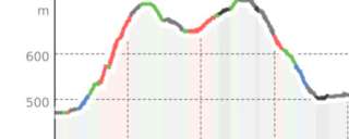
Hike approx. 12.6 km, 17 performance kilometers (2nd quarter 2024)
Elevation difference approx. 405 m, not suitable for strollers and wheelchairs
Refreshments at Restaurant Rütihof (open only Sat/Sun from 9 a.m.), Restaurant Unique (closed Tue/Wed), Restaurant Uschenriet (closed Mon/Tue, open from 11 a.m.), Café Cornetto (closed Monday afternoon).
From the guest info in the market hall, cross the main street, walk between Hotelplan and the town hall, then turn left via Marktgasse to Zaunplatz. The Landsgemeinde has been held here annually on the first Sunday of May since 1387. Now cross Zaunplatz southwards, pass Zaunschulhaus on the right and climb the stairs at the fountain.
Then go up Glärnischstrasse, pass Hotel Rössli on the left until the last southern residential block. Then turn left and ascend the Glarner circular route straight on, first on a service road, then after a stable turn right onto a meadow and forest path, bypass the Schuttsammler to the east and go uphill after a wooden shelter to the Hofrunse signpost (630 m, wooden bridge).
Beautiful view of Glarus with the three landslide hills Bergli, Sonnenhügel and Burghügel with castle chapel (1288) as well as Fridolinskirche (1964) and city church (1863).
Follow the hiking trail towards Schwändi/Schwanden, first left into the forest, then zigzag uphill to the next hiking trail signpost. Then straight uphill past the ski lift end at the power pole onto the forest road. Then turn left and follow the forest road for a longer time. At the next fork turn left downhill to Restaurant Rütihof. (open only Saturday/Sunday from 09.00 h).
Then turn right and walk on the asphalt road to the Schönau signpost (649 m). Continue right onto the Landesfussweg towards Schwändi/Lassigen (a red bench on the left). After 100 m follow the trail on the left, cross Hanslirunse, pass a red/yellow house and a carpentry with a red crane onto the country road. Then follow this road to the Weidli junction. Then turn right uphill to Vögeliweidli and on the asphalt road to Schwändi schoolhouse. From Schwändi there is a magnificent view of the Glarus mountains Kärpf (2794 m), Selbstsanft (3029 m), Bifertenstock (3425 m), Piz Russein/Tödi (3614 m) and Gemsfairen (2972 m). Descend left on Dorfstrasse, pass Restaurant UNIQUE (closed Tue/Wed) to the Schwändi/Adler Postbus stop. Then take the hiking trail left towards Mitlödi. Descend via Schibli/Niederrüti to Mitlödi, first on a road then on a hiking trail. At the entrance to Mitlödi, the Schiffmeisterhaus is on the right. On the descent, enjoy a nice view of the opposite village Sool and the Sernftal valley. Question 3: see supplement. Then pass the kindergarten and the reformed church (1725). Descend south of the church to the cantonal road and cross it as well as the railway and the Linth river.
At Holzbau Noser, continue straight on the bicycle path. At the Hoflädeli junction, turn right and pass the farm on the left to the Uschenriet forest restaurant. (Closed Mon/Tue, open from 11.00 h). Self-check at the restaurant (grey box). Follow the hiking trail left at the Robidog towards Ennenda. First gently ascending to a shed/red bench, then straight ahead past the stable on the left, then descend to the curve, then follow the trail left towards the Alterszentrum Bühli/Aeugstenbahn, at another Robidog turn right over the bridge. At the Aeugstenbahn turn left on the asphalt road to a staircase. On the lower street turn right to the train crossing to Café CORNETTO. (Closed Monday from 12.00 p.m.) Stamp the start card at Café Cornetto.
Then continue following the Fridliweg to Tridonic/Bikestation, then left over the Linth bridge and pedestrian crossing. After the bridge, turn right into Linthuferweg to the railway underpass. Through this back to Glarus station, past Hotel Glarnerhof and the community center back to the starting point Visit Glarnerland guest info. Good footwear is recommended.
Additional info
| Duration | 3 hours 40 minutes |