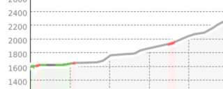
Mettmen - Kärpfscharte

The route is located in a wildlife protection area; a route requirement applies.
From the upper station of the aerial cableway (approx. 1600 m), pass by the Berghotel Mettmen and ascend to the northeastern end of the Garichti dam, then head southeast along the lake via point 1648 to the Matt alluvial plain. At the southern end of the plain, ascend mostly east of the Niderenbach through the narrow valley and reach the alpine path again at about 1760 m. Head south to the alpine buildings of Niderenalp and then continue always within the area of summer paths in the same direction ascending over the Chärpfbrugg (1853 m) to point 1923. In the area of the summer path, head southwest along the marking poles past point 2108 and Sunnenbergfurggele (2210 m) and ascend to about 2300 m. The last part to the Legler hut can be partially skied down. From the Legler hut (2271 m), traverse southeast through the steep southwest flank (around 35°) into the gully that ascends eastwards. At about 2480 m, turn south and pass east of point 2484 into the firn basin between Chli and Gross Chärpf. Ascend as high as possible under the rocks of the north face of the Gross Chärpf to then traverse northeast into the Chärpfscharte.
Additional info
| Duration | 4 hours 30 minutes |