Circular hike Berglimattsee

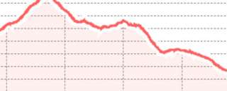
From the mountain station Kies-Mettmen we first hike along the left side of the lake to the end of the lake. Then turn left following the signpost Berglimatt, Matt. The trail leads through the climbing area Widerstein up to the Berglimattsee. Did you know that 250-300 million years ago there was intense volcanic activity in the Kärpf area? The deposited green Verrucano rocks reveal this to us. At the Berglimattsee we keep left towards Lauelialp, Engi. At point 1901 do not descend right to Engi but take the far left path towards Seebödeli, Nünenhütten. High above the Schwirrwand we walk through young forest. The old forest was heavily damaged by storm Vivian in 1990. Partial reforestation measures were initiated. Shortly before the Naturfreundehaus we enter a raised bog landscape and soon reach the dam wall of the Garichti reservoir again.
Additional info
| Duration | 3 hours 57 minutes |